Facebook Global Hackathon Finals - The Competition
Posted
on
in
Hackathons
• 2766 words
• 13 minute read
Tags:
Facebook, Menlo Park, California
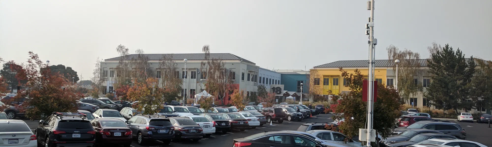
I woke up at 8:00 on Thursday morning. After a quick shower, I went down to eat some breakfast (provided again by Facebook). Then, we got on a bus and went over to Facebook HQ. This is a picture of building 18, one of the smaller buildings on the campus.
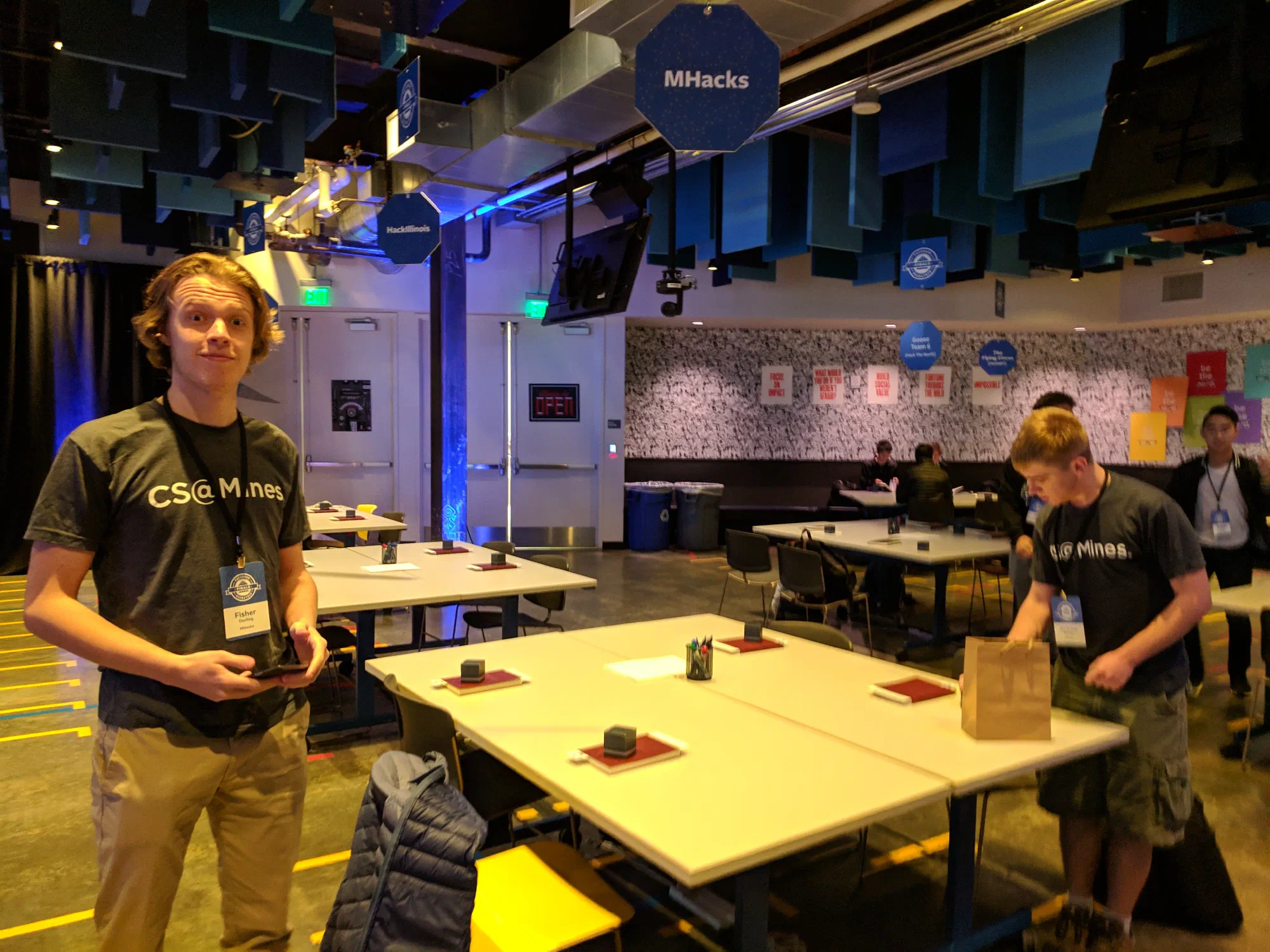
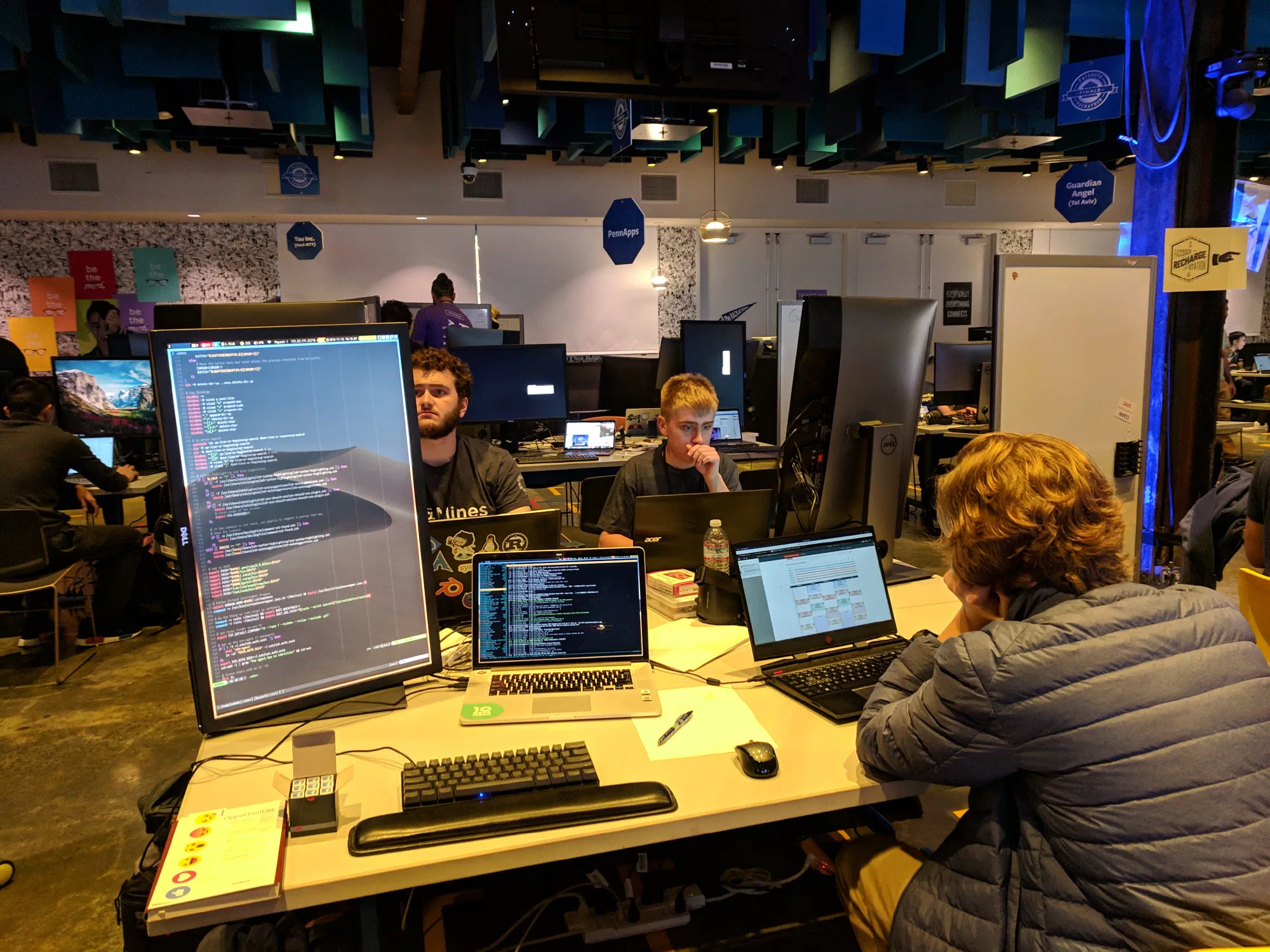
Once inside, we got to go see the area that we would be working in. It was a very nice space, and was set up for all 21 teams. They even had signs above our tables telling us which table was ours!
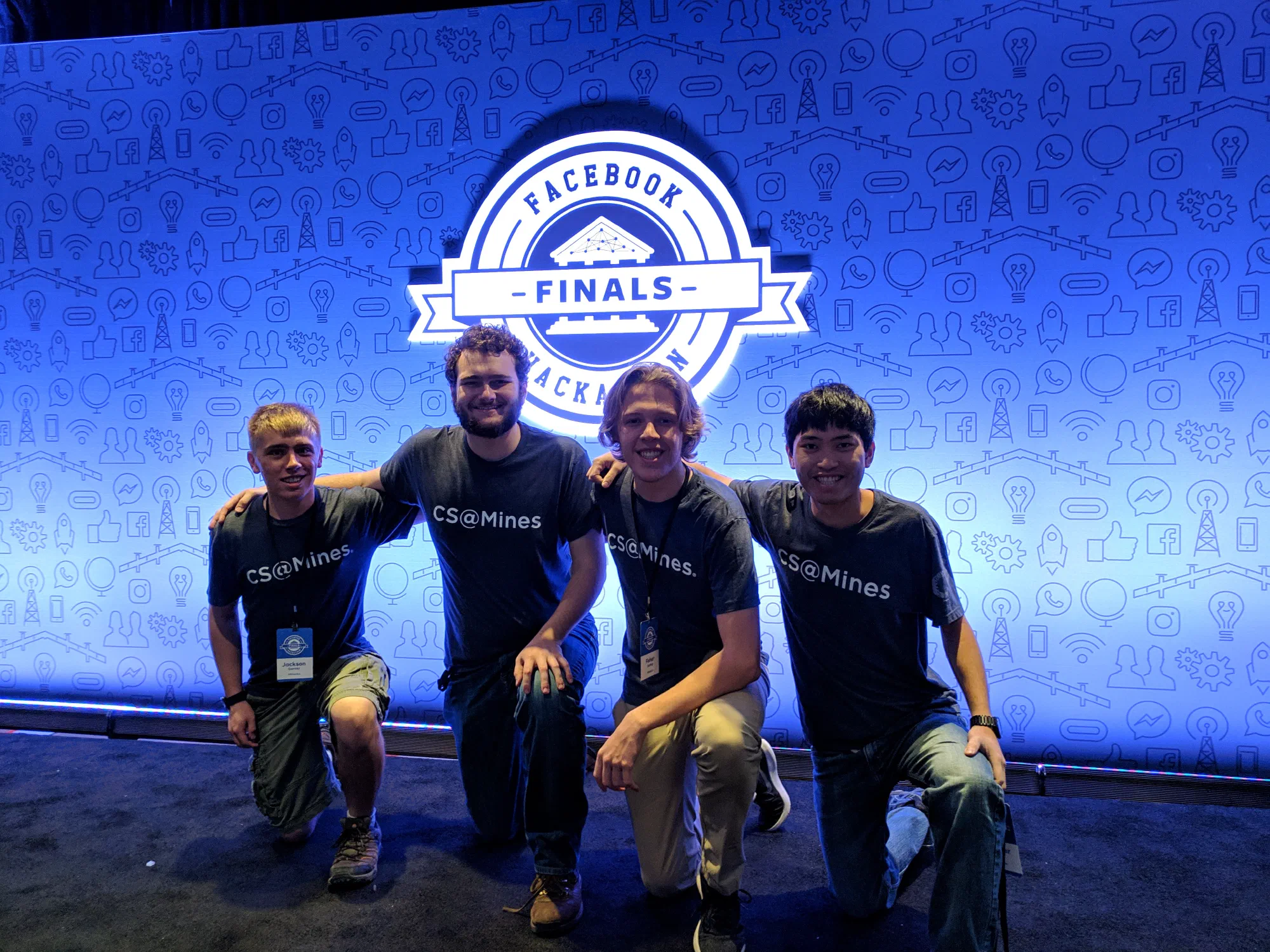
Then, after the obligatory team picture…
we got our workspace set up using the awesome monitors provided by Facebook.
After we had everything set up, we got to take a tour of the Facebook Headquarters. It is a pretty awesome campus! On our tour, we saw these cool maps on the ground which showed a correctly oriented map of the campus with a red dot indicating your location.
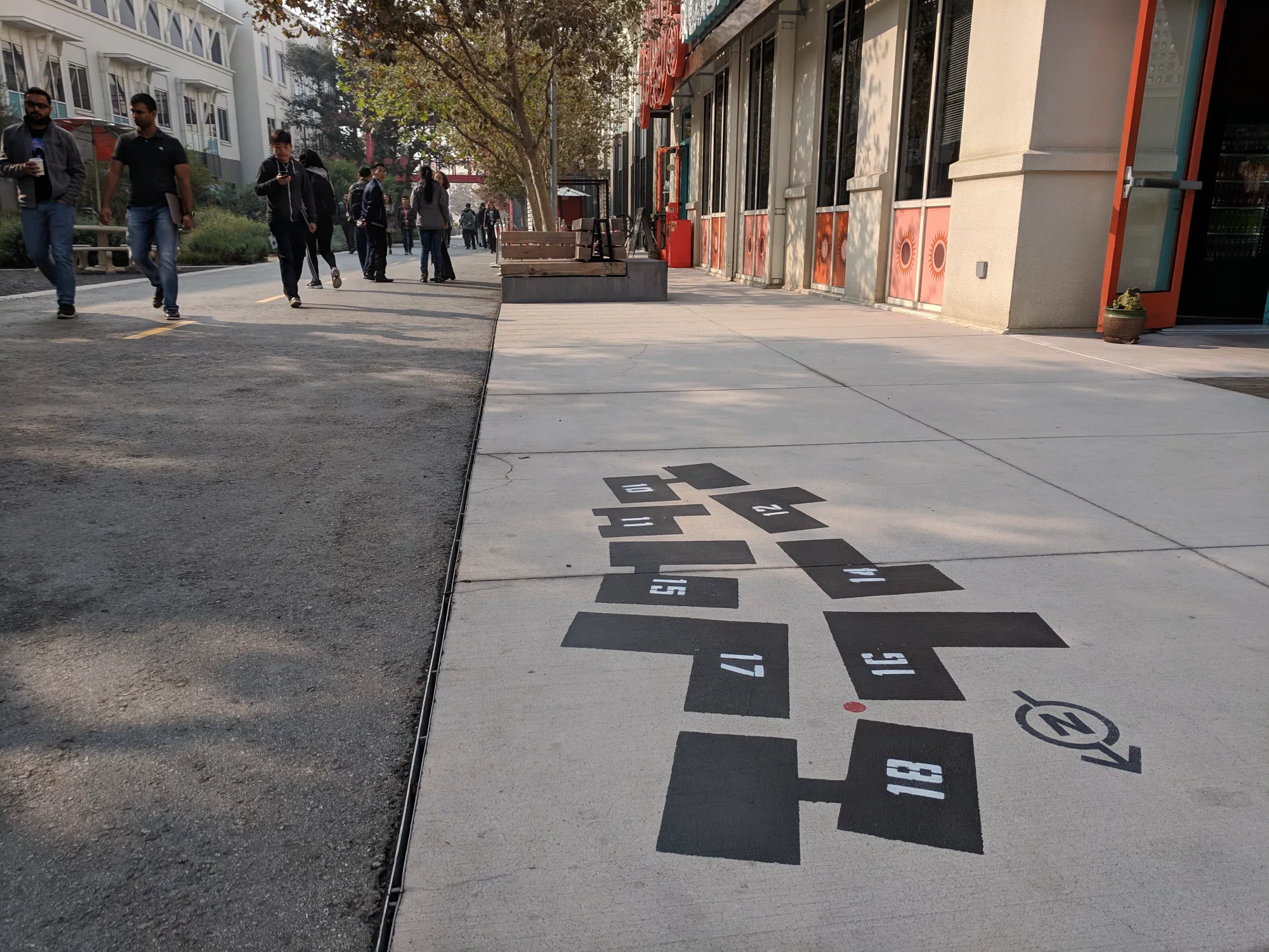
After the tour, we had a couple of minutes to continue getting set up and think of ideas. Fisher suggested that we digitize the maps like we saw outside. I thought that was a great idea. In fact, I’ve always wanted to create an app where you can just take a picture of the fire escape plan and then get an interactive map of the building using just that image. (Sidebar, I’ve always wanted to make that for Google Glass so that you could run into a building, look at the map quickly, and then it would show you where you have to walk to get to the room you are looking for.)
We thought of all sorts of other ideas too like VR mesh building, but everything seemed to be solidly in the AR/VR space.
By this time, it was about noon and we met our mentor from Facebook, Dan, who took us and one other team (from Carnegie Mellon) to lunch at one of the restaurants on the Facebook campus. The food is free for all employees (and to us), which is really neat.
We went to a Asian restaurant which was really good. They had the food laid out buffet style, and you could create your own Pho. Over lunch, we discussed our ideas with Dan and he thought they were great ideas.
Once we got back, it was time to start coding! After a final debate about what we wanted to do, we decided to go with the interactive map.
Writing All the Code
At this point, we faced our first challenge: what platform should we use? The
most obvious choice for us was to use ARCore on Android since we all had Android
phones. Unfortunately, between us we had approximately zero experience in
Android development. Sam had literally zero experience in Android development,
and I only had a slight idea of how to do it from my
Wireless Debugging project
during field session a couple summers ago (Reece did all of the UI stuff, so I
only ever delt with a bit of systems-level stuff with adb). Fisher had done
one super simple Android app in the past, and Jack was the most experienced of
us all having actually created an app 6 years ago when he was in 8th grade. We
also decided we would use Kotlin (which none of us had any experience with), and
since it’s so new, none of us had any experience with ARCore either.
Let’s just say, with those credentials, our chances of success seemed fairly slim with that option. So, we looked into other platforms such as WebAR. However, WebAR is not production-ready. We talked to a couple of mentors who have experience in AR/Android, and they recommended that we just go ahead and create an Android app.
We spent the next couple of hours installing Android Studio, getting our development environments set up, learning Kotlin, and mocking up some designs for our app.
Eventually, we got everything set up, and we all worked separately on small bits of the puzzle. Jack made a major breakthrough when he found a sample ARCore app which allowed the user to detect planar surfaces such as tables and walls in the world. I started on the UI for adding a new map or selecting an existing one. Sam started learning the AR APIs to determine what data it would give us. Fisher worked on getting GPS data from the phone. I also found a fire escape plan and took a picture of it.
Our strategy at this point was to try and use GPS data to locate the user on the fire escape map. Sam spent a while hard-coding the coordinates of the building we were in and also fixed up the picture that we took so that it would be more suitable for use in the app.
By midnight on Thursday, Sam and Fisher had connected their pieces together to create a proof-of-concept which used GPS and the hard-coded data to locate the user in the building. It was far from done, but we had something that (if everything else failed) we could demo.
There were three main features that were missing at that point.
- The map did not rotate itself correctly as you walked around the building,
- GPS data was slow; we only got a new location every 5 seconds.
- It only worked with a single, hard-coded image.
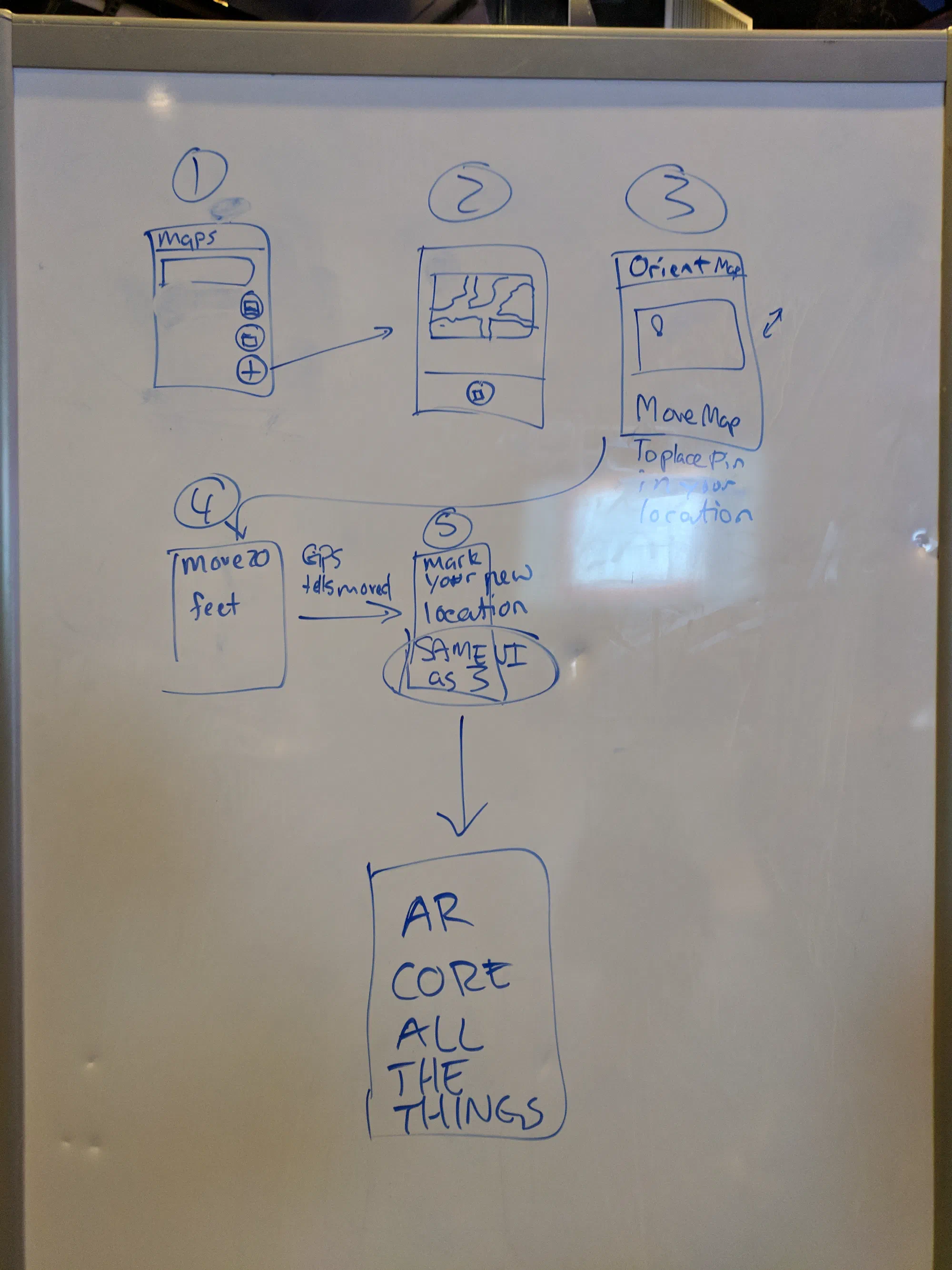
Sam had theorized that he could create and solve a linear system of equations to determine the position of the user just using the location of walls in the AR space. If he could do that, then the first two problems would be solved immediately. Two components would be necessary: an interface for lining up walls in the AR space with walls in the map-space; and the actual math for calculating the user’s position on the map given the marked wall locations. We deemed this to be a high-risk, high-reward problem, so we decided to have both Fisher and Sam work on it (Fisher on the wall selection GUI, and Sam on the computational linear algebra).
However, the risk of failure was high. To combat this, we decided to also prioritize an alternate method for computing the orientation of the map. To do this, Jack, worked on a method of using the compass APIs to get the orientation of the phone and update the map’s rotation in the AR overlay space accordingly.
I continued working on creating a UI for selecting maps and adding new maps. I was feeling fairly incompetent the entire evening, and I had lots of trouble just getting a list to show up properly with Material design patterns. My major contribution ended up being that I learned how to pass state between Android Activities (screens) using Intents. Still, I didn’t have anything working correctly until 02:00 on Friday. (In my defense, I did bounce around helping everyone else on the team throughout the hackathon.)
At 4:00, I decided it would be good to take an hour nap before getting back to it in the morning.
When I got up, Jack and I tried banging away at getting the map to orient correctly using compass data, but we were unsuccessful until we retrieved Sam from the couch he was sleeping on. Sam came over and, as if he had some revelation during his short sleep, paired up with Jack and wrote a ton of code that solved the linear system! Sam was using hard-coded wall data, and as soon as he got it working, the map oriented correctly and the red marker followed the person without even needing to use the compass or GPS for orientation and location! None of that was completed until there was less than an hour to go in the competition.
Meanwhile, I finished the feature which allowed users to load arbitrary images into the app (this ended up being critical for our preliminary demo). Fisher also got the wall alignment functionality working, and figured out how to pass data to Sam’s AR activity so that all of the math could use real data.
By this time, it was about 08:30, and we had to submit a survey describing our project to the judges by 09:30. Luckily, we had an extra hour until coding ended at 10:30. We realized that we didn’t even have a name for our project yet, and Sam suggested Hyper Map. Then, Fisher or Jack said, what about “HypAR Map”? There was immediate consensus around that name (consensus that you can only get when you are on 60 minutes of sleep for the last 24 hours), and thus HypAR Map was born.
I worked with Jack to fill out the survey to submit our project to the judges while Sam continued working on his linear equation solver. Sam, with an eye for potential failure, created an escape hatch in the application. If you pointed the phone at the ceiling, it would reset to use the hard-coded wall data. This gave us peace of mind in case everything started to fail.
With under an hour to go, Fisher and Sam finally managed to get all of the rotation data from Fisher’s code passed into Sam’s AR code, and… it didn’t work. A few more minutes of fiddling, and Sam fixed the bug! He did it just in time, too. The event organizer, Bambi, was literally in the middle yelling “10, 9, 8, …” for the final countdown as he made the last code change.
In the meantime, I started working on a logo for our project:
![]()
Luckily, that didn’t count as “coding” so we were able to finish that up after the code freeze at 10:30. Then came a frantic hour of preparation for preliminary demos. First, however, we had to cleanup the massive mess that we’d created on our table. We needed it to look presentable for the demo!
Demo Time
The way that judging worked is that every team had two minutes to pitch in front of all of the hackathon mentors. Then, the mentors would choose the top six teams to present to the actual judges, senior engineers from various parts of Facebook. If you made it to the top six, you were given three minutes to present.
Preparations included figuring out how to allocate the time to various parts of the demo, who would talk about each aspect of the project, what keywords to include (gotta have all the buzzwords if you want to win), how we were going to stand… basically everything. We only ran through the full demo a few times before we had to do our demo.
The actual demos were amazing. It was a really neat environment because we got to watch all of the other demos as well! Everyone’s projects were great, and I fully expected not to make it to the top six.
We had lunch at this point, and just waited for the judges to announce the top six. While we waited, I went around and talked to some of the other teams. It was super cool to talk to people and see what they had built.
Then the announcement came. We were the first team that they announced as being in the top six! We were so excited to be in the top six, but we’d seen the quality of the other projects, and we decided that we had to go all out if we had a chance of winning.
Thus, the next hour was another frantic hour of preparation. We had to figure out how to screenshare from the phone to the projectors, and hook it all up with the Facebook live stream that they were going to do for the final demos. The AV guys from Facebook were super helpful, and got us hooked up with a great setup.
We decided to tweak our demo to better highlight the features of our app. To do this, we decided to have Sam stand in the back of the room with the phone and, as we were talking about the project, he would mark a wall, and then walk around the building to demonstrate how well the tracking worked. We also reshuffled what each of us was going to talk about. We had gone through the general idea of what we were going to do and say, but we never got to fully rehearse our demo.
We were first to demo, which was kinda scary, but it ended up working out. The demo that we did on stage was the first time we had a done full-run of our demo; so as I was doing it, it did not feel good.
You can watch our demo (and the other five finalists) here (our demo starts at ~3:30). I’ve included a video of just our demo below:
After the demos were over, we definitely didn’t think that we would win. All of the other finalists had amazing demos, and I would have been happy to loose to any of them.
And the Winner Is…
After an agonizing wait, the judges came out and announced the winners. They started by announcing the runners up. We weren’t in that group. Then they announced third place. Guardian Angels, the team from Tel Aviv, won third. I was very happy for them, all of them were so nice. Then, second place was announced. As the judge was announcing it, he said “I think second place is pretty important because it gives away first place.” Good observation… He continued to troll us by talking about the second place app in the most nebulous way possible. He started out by saying “this product really brought a holistic view of the world to us”. I thought, well, that’s us. Then he said, “it used very impressive technology”. I was thinking, great, that’s really us! And then he said “and a great use of ML”. At that point, I realized that wasn’t describing our app any more. The second place prize went to Hedwig, a team from Melbourn, Australia. Their application was very impressive.
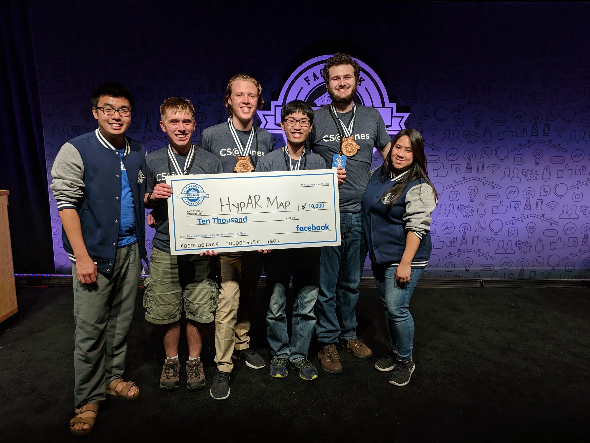
Then they called us up for the first-place prize! The prize was $10,000 for the team and an Oculus Rift with Touch for each of us!
You can watch a video of the award ceremony here (we get first at ~8:20).
Wow! What a great hackathon! I was so proud of how well our team worked together, and I was super happy with the result as well. I continue to be amazed by the quality of the competition, everyone at the hackathon made amazing projects.
At this point, we headed back to the hotel. Once back in my room I promptly took a nap. In fact, I napped too much. There was a celebratory event at 8:00 that evening, and I almost overslept it! Luckily, Sam called me to wake me up.
The event was really cool, there was great food, and we got to talk to the other competitors. We sat at a table with a team from Mexico, they were hilarious! There were games, and a bunch of different activities. Jack and I were super tired, and so we headed back on the early bus to the hotel.
After getting back, I went straight to bed. Hackathons are a test of endurance of both the brain and the body. If programming competitions are a sprint, then hackathons are marathons.
Edit (11-29-2018 13:40) Sam pointed out an error in the timeline of events. I have copied his words below.
I do want to metion [sic] one correction to the timeline. I was working on the linear algebra solver all through the night on a separate branch and it was calculating position correctly in the hard-coded room before I went to bed.
In the morning me and Jack were having tons of trouble with the compass data. We had a discussion and decided that we should focus on adding orientation to the wall-solving branch instead. We merged the branch into master and then spent an hour hacking out an orientation calculation.
So although the master branch went from GPS to walls in an hour, it took a lot lot longer than that to actually write the code. Don’t give us too much credit.
Its a great piece of storytelling, you don’t have to change it. I’m just setting the record straight that I can not, in fact, pull a fully interactive multivariate solver out of my ass in an hour. Much less when I’m operating on an hour of sleep.